
Contents
- Indigenous Knowledge: press your hand to each card
- At a Glance: facts and figures
- Field Notes: practical tips, listed in the Menu
- Economic Snapshot
- Underlined words: tap for a definition
Before you begin
How to read this magazine
Two chapters and twelve stories, about 45 minutes of reading in all. Chapter 1, Fire & Ice, explains how the granite towers, ice fields, fjords and steppe you will see were made. Chapter 2, First Peoples, introduces the Aonikenk, Selk'nam, Kawésqar and Yagán: how they lived, what they believed, and what happened to them. Each story stands on its own, so you can read them in any order, or one a day as you travel.
How to use this magazineThe four kinds of boxes, what you can tap, and what to read on each day of the trip
Every key figure is checked against a published source. The two Verified Data Logs list them, and the AI statement on the imprint page explains how this magazine was made.
Four kinds of boxes
- Indigenous Knowledge. Stories and words from Patagonia's Indigenous peoples, each named by nation. Press your hand on each of the twelve cards to fill your cave wall.
- At a Glance. The facts and figures, with an icon for the subject.
- Field Notes. Marcos's practical tips for what to look for. All of them are listed in the Menu.
- Economic Snapshot. How people made a living from the land.
Things you can do
- Tap any photo to open it full size, then swipe or use the arrows to move through the gallery.
- Tap underlined words for a short definition; all of them are also in the Glossary.
- Use Menu to jump to any story, and Home to come back to the cover.
- Switch to dark mode for reading at night.
- Your hands on the cave wall are saved on this device only.
- A printable PDF edition has the same content: download the PDF (14 MB).
Read it with the trip
| Day | Date | Where you are | Read |
|---|---|---|---|
| 2 | Fri 23 Oct | Flight and drive to Puerto Natales | 09 · 12 |
| 3 | Sat 24 Oct | Última Esperanza fjord | 05 · 10 |
| 4 | Sun 25 Oct | Torres del Paine | 01 · 03 · 11 |
| 5 | Mon 26 Oct | Cueva del Milodón (optional) | 07 |
| 6 | Tue 27 Oct | Border crossing to El Calafate | 02 · 04 · 06 · 08 |
| 7 | Wed 28 Oct | Upsala Glacier and Estancia Cristina | 04 |
| 8 | Thu 29 Oct | Perito Moreno Glacier | 04 |
Imprint
By Marcos Soto · Photography © Marcos Soto Photography · Design & editorial production: Pablo Soto Acevedo · Animista Studio
About this editionFull credits, how we used AI, licences
PATAGONIA — Fire, Ice & the First Peoples A field magazine of Argentine and Chilean Patagonia · First edition · 2026
By Marcos Soto, Tour Director Photography © Marcos Soto Photography, unless otherwise credited Design & editorial production Pablo Soto Acevedo · Animista Studio, San Pedro, Costa Rica
This magazine is shared free of charge with travellers and is not for sale. Third-party images and quotations are used under the licences named beside them.
How this magazine was made: our AI statement
We used an AI assistant (Claude, by Anthropic) to help research, organise and draft parts of this magazine, and to sketch early versions of its diagrams. We want you to know exactly what that means.
- People decided what is in it. Marcos chose the subjects from his years leading groups in Patagonia. Pablo directed the design and edited every page.
- Every fact points to a human source. Each key figure, date and claim was checked against published research, official records or reference works, listed in the Verified Data Logs. The AI is never cited as a source.
- Photographs are real. Every photograph is either Marcos's own or a credited, openly licensed image. No photograph in this magazine was generated or altered by AI.
- Indigenous knowledge is quoted, not invented. Stories, words and beliefs of the Aonikenk, Selk'nam, Kawésqar and Yagán peoples come from published ethnographies and from the communities' own organisations, and are named by nation. We do not reproduce ceremonies or knowledge that communities ask to keep private. Where sources disagree, we say so.
- Corrections are welcome. If you belong to one of these communities, or you spot an error, please tell your Tour Director so we can correct the magazine.
Chapter 1 · Fire & Ice
Carved by Fire and Ice
The Making of Patagonia
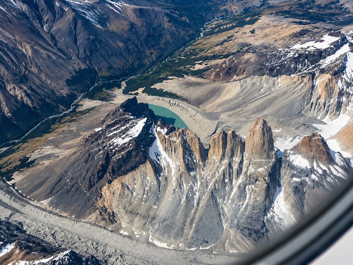
The Paine massif from the air: the laccolith's granite cut open by ice · Photo: Marcos Soto Photography · Patagonia 2019
Patagonia's skyline was built in two acts. Fire came first: molten rock rose into the crust and cooled into granite about 12.5 million years ago. Then ice spent the last few million years cutting that granite free, leaving towers, fjords and lakes that still carry the marks of the glaciers.
Stand on the shore of Lago Pehoé and the Cuernos del Paine look as if two mountains were stacked on top of each other. The lower walls are pale granite. The summits are dark, folded mudstone that was laid down on the floor of a Cretaceous sea. That colour line is a geological contact: the moment, frozen in rock, when a body of magma pushed its way between layers of older seabed and stopped.
Everything on this trip, from the granite towers of Torres del Paine to the blue walls of Perito Moreno, is the product of one long collision. The Pacific Ocean floor is sliding beneath South America, lifting the Andes and feeding them with magma. Westerly winds then dump some of the heaviest snowfall on the planet onto those peaks, and the ice that forms does the sculpting.
At a Glance
Patagonia in numbers
- Countries: Argentina and Chile; the Andes crest forms most of the border
- Southern Patagonian Ice Field: about 13,200 km² (2011), ~400 km long (48°–52° S)
- Largest glacier: Pío XI, 1,265 km², the largest in the Southern Hemisphere outside Antarctica
- Torres del Paine granite: about 12.5 million years old; the whole intrusive complex was assembled in roughly 160,000 years
- Precipitation: 2–11 m a year on the ice field; a few hundred mm on the steppe to the east
- Geological engine: subduction of the Nazca and Antarctic plates beneath South America
01Fire & Ice
Reading the Rocks
190 Million Years in One Landscape
Patagonia's story begins with a supercontinent coming apart. Around 188–153 million years ago, as Gondwana split and the Weddell Sea began to open, the crust of southern South America stretched and cracked. Huge volumes of silica-rich ash and lava erupted across what is now Santa Cruz province: the Chon Aike volcanic province, also called the Tobífera Series, which covers about 1.7 million km², including the continental shelf.
In the far south, stretching went further still. A narrow sea floored with oceanic-type crust opened behind the volcanic arc: the Rocas Verdes (“Green Rocks”) back-arc basin. Its remains survive today as the Sarmiento and Tortuga ophiolites in the Magallanes Region, slices of ancient sea floor stranded in the mountains.
In the Late Cretaceous the motion reversed. The basin was squeezed shut, and its floor sagged into a deep trough, the Magallanes (Austral) foreland basin. Turbidity currents poured sand and mud into it for millions of years. Those layers, roughly 98–86 million years old, became the dark Cerro Toro and Punta Barrosa formations that now cap the Cuernos del Paine.
The next act was magma. Between about 17 and 12 million years ago, molten rock rose into the folded sediments and froze into the granite cores of Fitz Roy (16.9–16.4 Ma) and Torres del Paine (about 12.5 Ma). Finally, from about 7 million years ago, glaciers began cutting down through the whole stack. Today's skyline is less than 10 million years in the making, carved from rocks up to 190 million years old.
Field Notes
How to read the Cuernos in three seconds
Look for the colour change. Pale grey-gold below is granite (about 12.5 Ma). The dark band above is Cretaceous seabed mud, baked and lifted by the magma. Where the two meet, the sediment is darker and harder: a “contact aureole” cooked by heat from below.
Diagram · Deep time on three scales
02Fire & Ice
Where an Ocean Ridge Dives
Raising the Southern Andes
The Andes exist because the Pacific floor is being pushed beneath South America. Off Patagonia, two oceanic plates do the pushing. North of about 46° S, the Nazca Plate moves east-northeast at 6.6–8.5 cm a year. South of it, the Antarctic Plate moves east-southeast at under 2 cm a year. The seam between them is the Chile Ridge, an active mid-ocean spreading centre.
Patagonia is one of the few places on Earth where a spreading ridge is being swallowed by a subduction zone. The ridge first reached the trench near the southern tip of the continent between about 18 and 14 million years ago. Since then, the meeting point of the three plates, the Chile Triple Junction, has crept north segment by segment. Today it sits off the Taitao Peninsula, near 46°30′ S.
A ridge cannot sink like an ordinary plate, because it is where new crust is born. As each segment went down, the two plates on either side kept pulling apart beneath the continent, opening a gap in the subducted slab: a slab window. Hot mantle welled up through that gap. Three things followed on the surface:
- A gap in the volcanic chain. Between Hudson volcano (about 46° S) and Lautaro (about 49° S), the Andes have almost no active volcanoes, because the normal supply of water-rich slab beneath them is missing.
- Lava plateaus in the east. Hot mantle melted beneath the steppe and flooded it with basalt. These are the flat-topped mesetas seen from Route 40 (see The Wind's Country).
- Uplift and exhumation. Thermochronology at Fitz Roy shows a pulse of rapid uplift and erosion about 10–8 million years ago, linked to mantle upwelling near 49° S.
The result is a mountain belt with two characters. The western Patagonian Andes are a vast granite batholith, the roots of an older volcanic arc, now drowned in fjords. To the east lies a fold-and-thrust belt of crumpled Cretaceous sediments, with younger granites such as Fitz Roy and Paine punched through them.
At a Glance
The tectonic engine
- Plates: Nazca and Antarctic (oceanic) beneath South American (continental)
- Nazca convergence: 6.6–8.5 cm/yr; Antarctic convergence: about 1.85 cm/yr
- Chile Ridge spreading: about 6.4–7.0 cm/yr since 5 Ma
- Ridge first subducted: about 18–14 Ma, in the far south
- Triple Junction today: off the Taitao Peninsula, Chile (~46°30′ S)
- Slab-window volcanic gap: about 46–49° S, Hudson to Lautaro
- Southern plate boundary: the Magallanes–Fagnano Fault, between the South American and Scotia plates, runs along the Strait of Magellan and Lago Fagnano
Diagram · The engine under southern Patagonia
Diagram · Where the ridge meets the trench
03Fire & Ice
Granite Cathedrals
The Towers of Paine and the Smoking Mountain
Torres del Paine: a frozen magma chamber, cut open
The Paine massif is a laccolith: a mushroom-shaped body of magma that spread sideways between sedimentary layers instead of erupting. It was injected about 12.5 million years ago, in several pulses, along a shallow fault in the Cretaceous mudstones. Grey gabbro and diorite pooled at the base; pale granite stacked above it in at least three sheets. U–Pb zircon dating shows the granite was built in about 90,000 years (Michel et al., 2008), and the whole bimodal complex in about 160,000 years (Leuthold et al., 2012). In geological terms, that is a blink.
The laccolith is more than 12 km across and up to 2.5 km thick, with a volume of about 88 km³. It is one of the best-exposed fossil magma chambers on Earth, which is why it is listed as an IUGS Geological Heritage Site. Glaciers sliced it open from floor to roof, so visitors can see its base, its feeder dyke and its contact with the host rock in a single view.
The granite is strong and cut by near-vertical cooling joints. When ice and frost attacked it, it broke along those joints into sheer walls and free-standing spires: the three Torres. The weaker sedimentary roof was stripped off almost everywhere, except on the Cuernos, where it survives as the dark “horns”.
Indigenous Knowledge · Aonikenk
Paine
Paine is usually explained as an Aonikenk (Tehuelche) word for “blue”, a reference to the colour of the lakes and the massif seen from the steppe. Some writers have proposed other origins, so we give it as the traditional explanation rather than settled fact.
Fitz Roy and Cerro Torre: the Chaltén Plutonic Complex
About 190 km to the north, the Fitz Roy group is older. Its granite belongs to the Chaltén Plutonic Complex, a gabbro-to-granite suite emplaced between 16.90 and 16.37 million years ago, over about 530,000 years (Ramírez de Arellano et al., 2012). It formed in the main volcanic arc, while Paine formed further east, behind it.
Fitz Roy rises to 3,405 m. The Aonikenk called it , “smoking mountain”, for the cloud banner that streams from its summit in the westerlies. Francisco P. Moreno named it Fitz Roy on 2 March 1877, after the captain of HMS Beagle. Lionel Terray and Guido Magnone made the first ascent on 2 February 1952.
Why are these peaks so steep? Thermochronology points to two pulses of erosion. Rapid uplift at Fitz Roy 10–8 million years ago was followed, at both massifs, by faster erosion from 7–4 million years ago as Patagonian glaciations began, and again from 3–2 million years ago as valley glaciers deepened. The study's conclusion: glacial erosion has been the main sculptor since about 7 Ma (Muller et al., 2024).
Indigenous Knowledge · Aonikenk
Chaltén, the smoking mountain
Long before it was named for a British sea captain, this peak was . In Aonikenk tradition it is also where the hero Elal was carried by a swan as a newborn and sheltered by birds for three days and nights, before he came down to teach the people fire and the hunt (full story in People of the Wind). The Aonikenk visited it as a sacred place on their summer journeys towards the Andes.
At a Glance
The great granite peaks
| Peak | Height | Granite age |
|---|---|---|
| Monte Fitz Roy (Chaltén) | 3,405 m | 16.9–16.4 Ma |
| Cerro Paine Grande | 2,884 m (GPS, 2011) | ~12.5 Ma |
| Torre Sur | ~2,500 m | ~12.5 Ma |
| Torre Central | ~2,460 m | ~12.5 Ma |
| Torre Norte | ~2,260 m | ~12.5 Ma |
| Cuerno Principal | ~2,100 m | granite base, Cretaceous cap |
Paine tower heights are approximate; no precise survey has been published.
Diagram · Inside the Paine massif
04Fire & Ice
Rivers of Ice
The Patagonian Ice Fields
The Pacific's westerlies arrive at the Andes loaded with moisture and are forced upward over the range. They cool and drop their water as rain at sea level and snow on the crest, between 2 and 11 m of water a year. That snow compacts into ice, and the ice collects into two great plateaus along the Chile–Argentina border.
The Northern Patagonian Ice Field covers about 4,365 km² and feeds 44 outlet glaciers (2011 survey), including San Rafael, whose front reaches the sea. The Southern Patagonian Ice Field stretches about 400 km from 48° to 52° S and covers about 13,200 km² (2011 survey), most of it in Chile. It is the world's second-largest contiguous ice field outside the polar regions.
Both are remnants of something far larger. At its peak, about 35,000 years ago, the Patagonian Ice Sheet ran from 38° to 56° S and covered about 492,600 km², enough ice to raise world sea level by about 1.5 m if melted. It began retreating by 25,000 years ago, collapsed fastest between 18,000 and 15,000 years ago, and broke into separate ice masses by about 15,000 years ago (Davies et al., 2020).
On Day 6 you visit the Glaciarium, El Calafate's Patagonian Ice Museum, opened in 2011; this story is good preparation for it.
Perito Moreno: the glacier that holds a lake hostage
Perito Moreno is 30 km long and about 259 km² in area. Its front stands up to about 60 m above Lago Argentino. Because it pushes across the lake to the far shore, it periodically seals off the Brazo Rico arm. Water behind the ice dam can rise up to 30 m above the main lake until it tunnels through and the ice bridge collapses. Ruptures have been recorded since 1917: repeatedly through the 20th century, then in 2004, 2006, 2008, 2012, 2013 (twice), 2016, 2018 and 2019.
For decades Perito Moreno was famous for staying roughly in balance while its neighbours shrank. That is changing: since 2020 its northern front has been retreating, possibly as a result of climate change. Some travel material still describes the front as more than 70 m high and the glacier as advancing; this magazine follows UNESCO (up to about 60 m) and the latest measurements, which show retreat.
Field Notes
Listening to a calving front
At the Perito Moreno walkways you will hear the glacier before you see it move. Sharp cracks are ice fracturing inside the front. The deep boom that follows, sometimes a few seconds later, is a block hitting the water. Calving now happens all along the front, so watch the whole wall, from one shore to the other.
At a Glance
Major outlet glaciers of the Southern Patagonian Ice Field
| Glacier | Area | Country | On this itinerary |
|---|---|---|---|
| Pío XI (Brüggen) | 1,265 km² | Chile | No |
| Viedma | 978 km² | Argentina | No |
| O'Higgins | 820 km² | Chile | No |
| Upsala | 765 km² | Argentina | Day 7 |
| Tyndall | 331 km² | Chile | No |
| Grey | 270 km² | Chile | Day 4 (possible viewpoint) |
| Perito Moreno | 259 km² | Argentina | Day 8 |
Losing ice. Most outlet glaciers are thinning and retreating, Upsala and Viedma among the fastest, while Pío XI has advanced. The Southern Ice Field lost an average of 13.5 km³ of ice a year in 1968–2000, rising to 38.7 km³ a year in 1995–2000. Satellite gravity and elevation data put the loss at about 20 Gt a year for 2000–2012.
Estancia Cristina: a family at the edge of the ice
Percival and Jessie Masters came from England to Río Gallegos in 1900. In 1914 they moved their family and animals by boat to a remote arm of Lago Argentino near the Upsala Glacier and started a sheep ranch; by 1916 it held 12,000 sheep. Their daughter Cristina died of pneumonia in 1924, aged 20, and the ranch took her name. When Los Glaciares National Park was created in 1937, the family stayed on under a permit, and in 1997 Janet, the widow of their son Herbert, turned the ranch into a lodge. The museum you visit is the old shearing shed.
Mate. Argentina's national infusion by law since 2013: yerba mate leaves steeped in a gourd and sipped through a metal straw, the bombilla. One person prepares it and passes it round, refilling it for each person in turn. Sharing a mate is a gesture of friendship.
Diagram · The two ice fields
Diagram · The ice-dam cycle
05Fire & Ice
Carved by Ice
Fjords, Lakes and the Shape of the Land
When the ice sheet melted back, it left a landscape built almost entirely by glaciers. West of the Andes, valleys gouged below sea level flooded to become the Chilean fjords and channels, a maze of islands that runs from Puerto Montt to Cape Horn. East of the range, the same valleys dammed by moraines filled with meltwater and became the great Andean lakes: Lago Argentino, Viedma, Buenos Aires/General Carrera and the lakes of Torres del Paine.
Lago Argentino, Argentina's largest freshwater lake, shows the scale of this carving. It covers about 1,500 km² and runs some 160 km into the Andes, filling a basin scoured out by ice. It drains east to the Atlantic through the Río Santa Cruz.
Five glacial features to spot from the coach or the boat
- Fjords: drowned U-shaped valleys with steep walls and a shallow lip (sill) at the mouth. The Última Esperanza fjord on Day 3 is one.
- Moraines: ridges of bulldozed rock debris that mark old ice fronts. Many lakes, including several in Torres del Paine, are held back by them.
- Hanging valleys and waterfalls: side valleys left high above a main valley that was cut deeper. Salto Grande in Torres del Paine pours between lakes of different levels.
- Erratics: boulders carried far from their source and dropped by the ice.
- Glacial milk: fine rock flour ground by glaciers, suspended in meltwater, which scatters sunlight and turns the lakes milky turquoise.
Why “Last Hope”?
In 1557 the governor of Chile sent the navigator Juan Ladrillero south to chart the coast and find a way into the Strait of Magellan from the Pacific. Threading the maze of channels, he reached this long arm of the sea and, by tradition, called it his última esperanza, his last hope of finding the passage. He did reach the Strait in 1558, the first to sail it in both directions. The Kawésqar had known these waters for thousands of years.
Field Notes
Pink in the shallows
Chilean flamingos feed in the shallows at Puerto Natales and at Laguna Nimez in El Calafate, filtering tiny shrimp and algae with their bills held upside down. The pink comes from pigments in that food; young birds are grey. Look for grey legs with pink “knees”. They are mostly winter visitors here, so in late October you may see a few, or none.
The Strait of Magellan and Tierra del Fuego
The Strait of Magellan is about 560 km long and narrows to about 3 km at its tightest point. Its course follows the Magallanes–Fagnano Fault, the transform boundary between the South American and Scotia plates. Ice then reshaped it: the First and Second Narrows (Primera and Segunda Angostura) are pinched between terminal moraines of two different ages. Tierra del Fuego may have stayed joined to the mainland until the early Holocene, around 9,000 years ago. Magellan's fleet entered the strait on 21 October 1520.
Indigenous Knowledge · Selk'nam
A drowned crossing
A Selk'nam tradition tells of the sea breaking through and cutting off a land route to the north. It is consistent with the post-glacial rise in sea level that geologists reconstruct for the strait. We offer it as a cultural parallel, not as proof.
Diagram · How a fjord is made
06Fire & Ice
The Wind's Country
Steppe, Mesetas and the Rain Shadow
Cross the border from Chile into Argentina on Day 6 and the land changes within an hour. Forest gives way to scrub, then to open grassland that runs to the Atlantic. The cause is the rain shadow. Air that has dropped metres of snow on the ice field descends the eastern slope, warms and dries. El Calafate, about 80 km by road from Perito Moreno, receives only about 161 mm of rain a year (1991–2020 average), less than many deserts.
Indigenous Knowledge · Aonikenk
Where the wind comes from
In the Aonikenk account of creation, the world began in darkness. The creator Kóoch wept, and his tears became the first sea. Then he sighed, and his sigh became the wind, which swept away the mists and let in the light. For the people of the steppe, the wind that rocks your coach was the breath that started the world.
The steppe is not flat. It is a staircase of mesetas, table-topped plateaus capped by gravel or basalt. Many of these basalts were erupted in the last 12 million years, when the slab window let hot mantle melt beneath the region (see Where an Ocean Ridge Dives). The flat caps resist erosion, so rivers and wind cut the softer layers around them into cliffs and canyons. In the east of Santa Cruz, older silica-rich rocks of the Chon Aike province form the Deseado Massif.
At a Glance
West vs. east of the Andes (~50° S)
| Topic | Pacific side | Ice field crest | Steppe (El Calafate) |
|---|---|---|---|
| Precipitation | very high | 2–11 m water/yr | ~161 mm/yr |
| Landscape | fjords, rainforest | ice, nunataks | grass steppe, mesetas |
| Dominant rock | Patagonian Batholith granite | granite, metamorphics | Cretaceous–Cenozoic sediments, basalt |
El Calafate and its berry
El Calafate, founded in 1927, is named after the calafate shrub (Berberis microphylla), a thorny bush with yellow flowers and dark blue berries. A popular saying, often attributed to the Tehuelche, promises that whoever eats the berry will return to Patagonia.
Field Notes
Respect the wind
The westerlies that build the ice fields are the same ones you feel on the steppe. Gusts on exposed viewpoints and lake shores can knock a person off balance and carry grit hard enough to sting. Keep camera straps around your neck, hold car doors with two hands, and face downwind when a gust arrives. In late October expect roughly 1–14 °C in El Calafate, 14 to 14½ hours of daylight, and the start of the windiest season: in Torres del Paine some trails close when the wind exceeds 80 km/h.
Pali Aike: Patagonia's youngest volcanoes
Northwest of the Strait of Magellan, straddling the border, lies the Pali Aike volcanic field: about 4,500 km² holding roughly 468 volcanic vents, including about 100 explosive maar craters up to 4 km wide. Activity began about 3.8 million years ago. Eruptions at the Diablo Negro lava field buried artefacts at Pali Aike Cave, so the youngest happened while people were living here, roughly 10,000 to 5,000 years ago. Nearby Fell's Cave, first used some 13,000 years ago, is among the oldest human sites in Patagonia (see First Footprints).
Field Notes
Look up: condors on the wind
The Andean condor rides the westerlies. Its wings can slightly exceed 3 m, and it can cover 200 km in a day while barely flapping. Adults are black with a white collar and white wing panels; males have a fleshy comb, females have red eyes, and young birds stay brown until about six years old. Scan the cliffs of Cerro Benítez (Day 5) and the skies of Torres del Paine (Day 4). It is listed as Vulnerable worldwide.
Diagram · The rain shadow
Verified Data Log
Chapter 1: the facts behind the pages
26 facts in this chapter, checked against 36 published sources.
Show the sourcesItem, value, location and source for every fact
| Item | Value | Coordinates / location | Source |
|---|---|---|---|
| Monte Fitz Roy | 3,405 m (USGS; UNESCO gives 3,375 m); first ascent 2 Feb 1952 | 49°16′17″ S, 73°02′36″ W | USGS, Williams & Ferrigno (eds.), Prof. Paper 1386-I; Arko, 1965, American Alpine Journal |
| Chaltén Plutonic Complex | 16.90 ± 0.05 to 16.37 ± 0.02 Ma (U–Pb zircon) | Fitz Roy massif | Ramírez de Arellano et al., 2012, Tectonics |
| Torres del Paine granite | 12.593 ± 0.009 to 12.431 ± 0.006 Ma | ~51°00′ S, 73°00′ W | IUGS Geoheritage; Leuthold et al., 2012 |
| Paine laccolith size | >12 km across, ≤2.5 km thick, ~88 km³ | Cordillera del Paine | IUGS Geoheritage |
| Paine host rocks | Cerro Toro & Punta Barrosa Fms, ~98–86 Ma (Late Cretaceous) | Magallanes Basin | IUGS Geoheritage |
| Cerro Paine Grande | 2,884 m (GPS, Aug 2011) | Torres del Paine NP | Rada, 2012, American Alpine Journal |
| Glacial exhumation | Main driver since ~7 Ma; pulses 7–4 Ma and from 3–2 Ma | Fitz Roy & Paine | Muller et al., 2024, Tectonics |
| Chile Ridge subduction onset | ~18–14 Ma (sources differ); junction now at 46.5° S | Triple Junction now off Taitao Peninsula | Cande & Leslie, 1986, JGR, via Gallego et al., 2011, Lithosphere; Breitsprecher & Thorkelson, 2009, Tectonophysics |
| Chon Aike volcanic province | 188–153 Ma; ~1.7 million km² incl. continental shelf | Santa Cruz, Deseado Massif | Pankhurst et al., 2000, Journal of Petrology; Sruoga et al., 2010, Rev. Asoc. Geol. Argentina |
| Southern Patagonian Ice Field | ~13,200 km² (2011); ~400 km long | 48°–52° S | Davies & Glasser, 2012, Journal of Glaciology |
| Northern Patagonian Ice Field | 4,365 km²; 44 outlet glaciers (2011) | Aysén, Chile | Davies & Glasser, 2012, Journal of Glaciology; USGS Prof. Paper 1386-I (older survey: ~4,200 km²) |
| Patagonian Ice Sheet (max) | ~492,600 km²; ~1.5 m sea-level equivalent; ~35 ka | 38–56° S | Davies et al., 2020 (PATICE) |
| Perito Moreno Glacier | 259 km² (2007); 30 km long; front up to ~60 m above the lake | 50°30′ S, 73°12′ W | Koch et al., 2025, Communications Earth & Environment; UNESCO World Heritage Centre, Los Glaciares (145); ESA, 2007 |
| Lago Argentino | ~1,500 km²; ~160 km long | Santa Cruz, Argentina | Van Wyk de Vries et al., 2022, JGR: Earth Surface; UNESCO, Los Glaciares |
| Los Glaciares NP | UNESCO World Heritage 1981, criteria (vii)(viii) | Santa Cruz, Argentina | UNESCO |
| Pali Aike volcanic field | ~4,500 km²; 468 vents; 3.78 Ma to Holocene | Santa Cruz / Magallanes border | Haller, Németh & Meister, 2005, XVI Congreso Geológico Argentino; Smithsonian Global Volcanism Program |
| Strait of Magellan | ~560 km long; min. ~3 km wide; entered 21 Oct 1520 | 52–54° S | Encyclopaedia Britannica, “Strait of Magellan” |
| El Calafate rainfall | 160.8 mm/yr (1991–2020) | El Calafate | Servicio Meteorológico Nacional, normales 1991–2020 |
| Glaciarium | Patagonian Ice Museum, opened 2011 | El Calafate | La Nación, 2011 |
| Estancia Cristina | Founded 1914 by Percival and Jessie Masters; 12,000 sheep (1916); renamed after Cristina (d. 1924); lodge since 1997 | Brazo Cristina, Lago Argentino | Estancia Cristina, History; La Nación, 2024 |
| Mate | National infusion of Argentina, Ley 26.871 (2013) | Argentina | Argentina.gob.ar, El mate |
| Última Esperanza name | Juan Ladrillero expedition 1557–58, first to sail the Strait both ways; “last hope” naming by tradition | Seno Última Esperanza | Memoria Chilena; Campbell, 2005, Álbum «Última Esperanza», introduction |
| Chilean flamingo | Phoenicopterus chilensis; Near Threatened; mainly a winter visitor in Magallanes | Puerto Natales; Laguna Nimez, El Calafate | MMA Chile, species file; Smithsonian's National Zoo, flamingo facts |
| El Calafate | Founded 7 Dec 1927; named after Berberis microphylla | Santa Cruz, Argentina | Argentina.gob.ar; Advances in Horticultural Science |
| Andean condor | Wingspan can slightly exceed 3 m; up to 200 km a day; Vulnerable (IUCN, 2020) | Cerro Benítez; Torres del Paine | MMA Chile, species file, citing Lambertucci, 2007 and IUCN, 2020; Kidd, 2014, Animal Diversity Web; CONAF |
| Late-October conditions | October average, El Calafate: 1.3–13.5 °C; daylight 14–14½ h (calculated); trails close above 80 km/h wind | El Calafate; Torres del Paine | Servicio Meteorológico Nacional, El Calafate Aero, normales 1991–2020; CONAF, Torres del Paine bulletin |
Geological epochs used: Early–Late Jurassic (201–145 Ma); Late Cretaceous (100.5–66 Ma); Miocene (23–5.3 Ma); Pliocene (5.3–2.6 Ma); Pleistocene (2.58 Ma–11.7 ka); Holocene (11.7 ka–present), per the ICS International Chronostratigraphic Chart.
Chapter 2 · First Peoples
Thirteen Thousand Years at the End of the World
The First Peoples of Patagonia
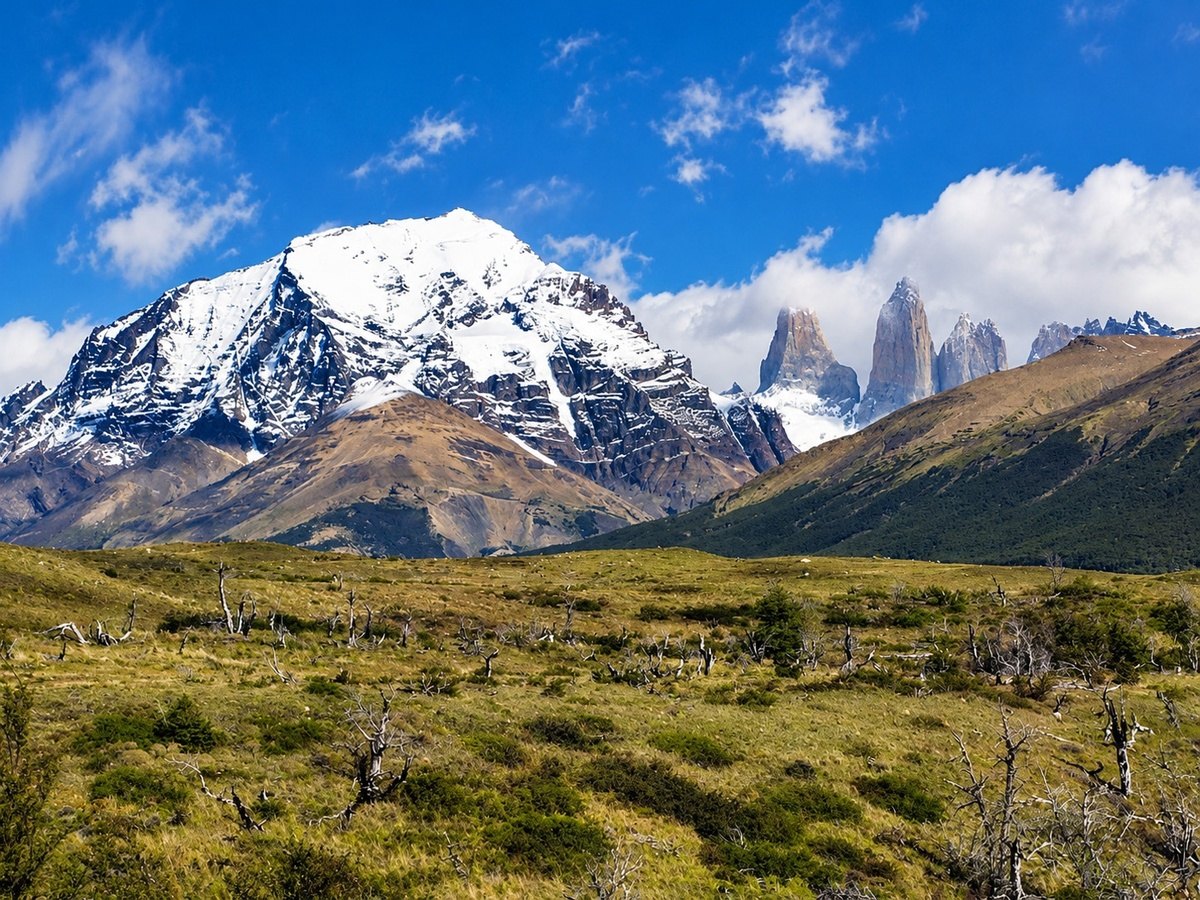
The steppe below the Paine massif, land walked by the Aonikenk · Photo: Marcos Soto Photography · Patagonia 2017
Long before the first European sail appeared in 1520, Patagonia was home. Four peoples shaped their lives around its two great environments: the Aonikenk and Selk'nam walked the steppe after guanaco, while the Kawésqar and Yagán lived on the water, in bark canoes that carried a fire in their centre. Their descendants live here still.
People reached the southern tip of the Americas soon after the ice began to retreat. By about 10,000 years ago, hunters were camping in caves near today's Puerto Natales; by about 9,000 years ago they were painting their hands on cliff walls in Santa Cruz. Over the following millennia they developed two very different ways of living in the same cold, windy land.
On the steppe, life followed the guanaco. Families moved between winter camps in sheltered lowlands and summer camps near the Andes and their lakes, carrying shelters made of hides. In the channels and fjords of the west and south, life followed the tide. Families paddled from cove to cove, gathering shellfish, hunting sea lions and moving on before a beach was exhausted.
Each people had its own language, its own stories about how the world began, and its own ceremonies for turning children into adults. This chapter introduces them in their own terms, as far as published sources and their descendants allow.
At a Glance · Peoples
The four nations of southern Patagonia
| People (own name) | Also called | Way of life | Homeland | Today |
|---|---|---|---|---|
| Aonikenk | Southern Tehuelche, “Patagones” | Steppe hunters (on foot, then on horseback) | Strait of Magellan to the Río Santa Cruz | Communities in Santa Cruz, such as Camusu Aike |
| Selk'nam | Ona | Island hunters of guanaco | Northern and central Tierra del Fuego (Karukinka) | Communities in Tierra del Fuego; recognised in Chile in 2023 |
| Kawésqar | Alacalufe | Canoe people | Western channels, Gulf of Penas to the Strait of Magellan | Communities at Puerto Edén, Puerto Natales and Punta Arenas |
| Yagán | Yámana | Canoe people | Beagle Channel south to Cape Horn | Community at Villa Ukika, Puerto Williams |
Each nation has living communities; names are given as they use them.
Indigenous Knowledge · All four nations
How we name them
Most familiar names for these peoples were given by outsiders. “Patagones” comes from Antonio Pigafetta's account of Magellan's 1520 voyage, which described the people at San Julián Bay as giants. “Ona” and “Alacalufe” were used by neighbours and settlers. This magazine uses each nation's own name and gives the older name once, so you can recognise it in museums and old books.
Diagram · Homelands and itinerary
07First Peoples
First Footprints
Hunters at the Edge of the Ice
The first Patagonians arrived while glaciers still filled the Andean valleys. They hunted animals that no longer exist: a native horse, Hippidion, and the giant ground sloth Mylodon, alongside the guanaco that would sustain their descendants for thousands of years.
At a Glance · Deep human time
Three caves, three clocks
| Site | Where | Oldest evidence | What it tells us |
|---|---|---|---|
| Fell's Cave | Río Chico, Magallanes (52°02′ S) | ~11,000 radiocarbon yrs (~13,000 cal yrs) | People hunted extinct horse and sloth with fishtail points |
| Cueva del Milodón | Cerro Benítez, 25 km NW of Puerto Natales | Mylodon 13,500–10,200 yrs | Giant sloth and humans shared the land |
| Cueva de las Manos | Río Pinturas, Santa Cruz | ~9,300 yrs (UNESCO) | Over 8,000 years of painting tradition |
Fell's Cave: the oldest hearths
In a basalt-roofed rock shelter on the Río Chico, near the Pali Aike volcanoes, the American archaeologist Junius Bird excavated hearths in 1936. Charcoal from the oldest layer gave radiocarbon ages of about 11,000–10,100 years, roughly 13,000–11,500 calendar years ago. Among the bones of horse, ground sloth and guanaco lay 15 finely worked stone spear points with a flared base. Archaeologists now call them fishtail points, and Fell's Cave is the reference site for them across South America.
Cueva del Milodón: the cave of the giant sloth (optional activity, Day 5)
About 25 km northwest of Puerto Natales, on the slopes of Cerro Benítez, the largest cave in Magallanes holds the story that launched a hundred travel books. In 1895 the German settler Hermann Eberhard found a piece of skin, still covered in coarse hair, that turned out to belong to Mylodon, a ground sloth that died out at the end of the last Ice Age, roughly 13,500–10,200 years ago (radiocarbon dates). Tools, burnt stone and human remains show that people used the caves of Cerro Benítez too.
Cueva de las Manos: hands across eight thousand years
In the canyon of the Río Pinturas, Santa Cruz, hundreds of hands reach out of a cliff overhang. They are stencils: a hand pressed to the rock, pigment blown around it through a tube of bone. The colours came from the land itself: iron oxides for red and purple, kaolin for white, natrojarosite for yellow and manganese oxide for black. Guanacos, hunting scenes and geometric figures share the walls. UNESCO dates the art from about 9,300 to 1,300 years ago and inscribed the site as a World Heritage Site in 1999.
Indigenous Knowledge · Gününa küna
Who painted the walls?
Among the northern Tehuelche (Gününa küna), rock paintings were attributed to Elemgasem, a powerful being who lived inside a cave and was the master of the animals. In the story, he could only be killed by lightning. The painters themselves left no written explanation; the story tells us how later generations understood the marks their ancestors left.
Field Notes
Count the left hands
Cueva de las Manos is far north of this route, so look at the photo in this story and count how many of the stencils are left hands. A common explanation is practical: a right-handed painter pressed the left hand to the rock and held the blowpipe in the right. Then compare sizes: hands of different sizes sit side by side on the same wall.
08First Peoples
People of the Wind
The Aonikenk of the Steppe
The Aonikenk, the southernmost of the Tehuelche peoples, lived between the Strait of Magellan and the Río Santa Cruz. Their name means “people of the south”. When Magellan's crew met them at San Julián Bay in 1520, the chronicler Antonio Pigafetta called them and described them as giants, a legend that gave the whole region its name.
Indigenous Knowledge · Aonikenk
How Patagonia was made
In the beginning there was only darkness and Kóoch, the creator. Kóoch's tears became the first sea, , and his sigh the wind (see card 04). From the sea he raised an island and filled it with birds, animals and fish.
Later came Elal, the hero. Born of the giant Noshtex and of Teo, the Cloud, he was carried by a swan to the summit of Chaltén, where birds sheltered him for three days and nights. Elal brought the animals to Patagonia, away from the island's cruel giants, and taught the people fire, the bow and arrow, how to hunt, and how to live rightly. Then he forbade anyone to worship him and flew home on his swan. When an Aonikenk dies, the spirit Wendeunk, who keeps count of each person's deeds, guides them to Elal's island across the sea.
If the clouds lift and you glimpse Fitz Roy's summit, remember: in Aonikenk tradition, this is where the first teacher came down to the land.
A day in a steppe camp
Families lived in bands of several dozen households, each with its own hunting grounds and a chief whose authority was limited mostly to deciding when to move and how to organise the hunt. Camps () were lines of tents made from guanaco hides stretched over poles, their backs turned to the west wind.
- Men hunted. On foot, they used small bows with sinew strings and stone-tipped arrows. After the arrival of the horse, the boleadora became the main weapon: two or three stones joined by cords, thrown to tangle the legs of a guanaco or the neck of a rhea (ñandú or choique).
- Women made the camp. They dried guanaco skins in the sun, scraped them with flint, softened them with fat and liver, and sewed them with guanaco sinew into cloaks. The finished cloaks, known in Spanish as , were worn fur-side in and painted on the outside: red ochre grounds with black crosses, blue and yellow stripes, or white-blue-red zigzags. A family in mourning changed the design.
- Everyone hunted something. During a horseback hunt, women formed the encircling line and took smaller game: skunks, maras and armadillos.
Economic Snapshot
The guanaco economy
One animal supplied almost everything: meat and fat for food; hides for tents and cloaks; sinew for thread and bowstrings; bone for tools. Rhea supplied meat, eggs and feathers for trade. Fresh water decided the routes, and the movements of the herds decided the calendar.
The horse changes everything
The Aonikenk first encountered horses brought by the Spanish in the 16th century. By the 18th century the horse had transformed their world. Hunting became faster and mainly a men's activity on horseback, and the main direction of travel shifted from east–west to north–south, along two great routes: one following the cordillera, one following the coast. In the 19th century, trading trips to Carmen de Patagones and Punta Arenas became the centre of the economy. Guanaco skins, feathers and cloaks were exchanged for flour, sugar, tobacco, metal tools and alcohol.
Diagram · The Aonikenk seasonal round
Field Notes
Bolas on the wind
In El Calafate's shops you will see for sale. The real ones were not ornaments: the stones were carefully chosen and grooved, and the cords were made from rawhide, guanaco neck or rhea tendon. The two-ball type used for rheas was called the .
09First Peoples
Karukinka
The Selk'nam of Tierra del Fuego
The Selk'nam lived on the great island of Tierra del Fuego, which they call Karukinka. Their ancestors most likely crossed from the mainland thousands of years ago, before the Strait of Magellan flooded. Around 1880 they numbered about 4,000 people. They shared the island with the related Haush in the far southeast and with the canoe-going Yagán along the southern shore.
At a Glance · Selk'nam
From 4,000 to near silence — and back
- c. 1880: about 4,000 people
- 1919: 276 counted by Gusinde
- 1974: death of Ángela Loij, remembered as the last Selk'nam of unmixed ancestry
- 1994–1998: Argentina recognises the Rafaela Ishton community and restores 35,000 ha of land under provincial Law 405
- 2023: Chile recognises the Selk'nam as an Indigenous people (Law 21.606)
- Today: 2,761 self-identified in Argentina (2010) and 1,444 in Chile (2017), many working to revive language, song and ceremony
Life on the island
The Selk'nam were walkers and hunters. Guanaco was their most important resource, hunted by men with bows, arrows and bolas, and with the help of the Fuegian dog, a tamed form of the culpeo fox. Everyone worked except small children, the old and the sick.
- Women did nearly all the domestic work: gathering food, cooking, weaving baskets, curing hides, collecting firewood and water, caring for children, carrying the household's goods and putting up the shelter at each new camp. With the children they gathered eggs, fungi, berries and shellfish.
- Men made tools of stone, bone and wood, and supplied the meat and hides for food, clothing and shelter. Skilled bow-makers and arrow-makers held honoured titles.
- A stranded whale was a gift for everyone. When one beached, the whole community gathered for a long celebration.
Woven by the sky
Selk'nam society was woven together by the sky. Families lived in shared hunting territories called , grouped into four “skies” (cielos). A person had to marry someone from a different sky. Plants and animals were linked to the sky of the mythical ancestor they were thought to embody, so the whole living world belonged to the same order as the people.
Indigenous Knowledge · Selk'nam
Spirits and healers
The Selk'nam recognised Temáukel, a distant supreme being who kept the world in order, and a creator-ancestor, Kénos, who shaped the land and its customs. Healers called acted through a spirit called waiuwin, entered trance as they sang, could influence the weather and competed against one another in contests of power. Their songs, recorded in the 20th century, are kept by archives in Chile and Argentina today.
The Hain
The Hain was the Selk'nam's great ceremony of initiation, which could last several months. Young men () were led into a great ceremonial hut, where they were confronted by spirits: men of the community, painted in red, white and black and masked in bark and hide. After their ordeal the initiates were shown that the spirits were their own relatives, and were taught the story behind the ceremony: that long ago women had ruled through the same masks, until the men discovered the secret and turned it against them.
The last Hain was held in 1923 and was photographed by the priest and ethnographer Martin Gusinde. His images of painted spirit figures, such as the Shoort (also spelled Soort) and Xalpen, have become some of the most widely reproduced pictures of Patagonia, and are often used without context.
Field Notes
Before you buy a “Selk'nam” souvenir
Hain spirit figures are printed on mugs, T-shirts and magnets in shops in Punta Arenas, Puerto Natales and El Calafate. For the Selk'nam, the Hain was a sacred and secret ceremony. If you want a keepsake, look for pieces made or authorised by Selk'nam community organisations.
10First Peoples
Fire on the Water
The Canoe Peoples, Kawésqar and Yagán
West and south of the steppe, the land breaks into thousands of islands, fjords and channels. Here two peoples made the sea their road. Their whole life fitted into a canoe: a family, its dog, its tools, and a fire that was never allowed to go out. According to the traditional account, Magellan's crew saw so many of these fires along the shores in 1520 that the main island became known as Tierra del Fuego, the Land of Fire.
The canoe: a floating home
- Hull of bark. Sheets of bark, usually from southern beech (coigüe), were shaped with heat, sewn together and stretched over a frame of wooden ribs. Kawésqar seams were stitched with whale-sinew thread.
- Size. The old Kawésqar was 8–9 m long; Yagán canoes were 3–5 m long and about 1 m wide, carrying 3–7 people.
- The hearth. A fire of slow-burning embers was kept in a special enclosure at the centre of the canoe, for warmth and cooking.
- Later boats. The three-plank dalca was adopted from the Chono people to the north; dugout canoes came only with European metal tools.
Diagram · Inside a Yagán bark canoe
Kawésqar: people of the western channels
The Kawésqar ranged from the Gulf of Penas to the Strait of Magellan, one of the wettest and stormiest coasts on Earth. Men hunted sea lions with harpoons or caught them alive in nets of leather thongs, and took otters and seabirds. Women gathered shellfish, often diving for the richest beds, their bodies covered in clay and animal fat against the cold, and carried the catch in baskets they wove themselves. They never farmed.
Indigenous Knowledge · Kawésqar
Xólas and Ayayema
The Kawésqar recognised Xólas, a solitary creator who made everything, including customs and morals, and guided human life. Against him stood Ayayema, an evil spirit known by its stench, who brought misfortune, illness and death. Dreams were the bridge between this world and the beyond. A healer, the , treated serious illness and predicted the weather. Young men and women were initiated together in the , usually held when a whale stranded and food was plentiful, and which could last six to ten weeks.
Yagán: the world's southernmost people
The Yagán (Yámana) lived along the Beagle Channel and the islands south to Cape Horn. In their canoes, women paddled and dived for shellfish: mussels, limpets and abalone; they were the only swimmers in the family. Men steered, cared for the children, fished with hook and line and hunted sea lions, seals, otters and whales. Families travelled alone and came together in larger groups only when food was plentiful, such as when a whale stranded. Their diet was rich in fat, which helped them withstand the cold; they wore little clothing, coated their skin with animal grease and rested in a deep squat to conserve heat.
Indigenous Knowledge · Yagán
Watauineiwa, the owner of all that exists
The Yagán prayed to Watauineiwa, “the owner of all that exists”, who gave and took life and provided plants and animals. Teenage boys and girls were initiated together in the Ciexaus, a ceremony of physical trials and teaching. A later, men-only rite, the Kina, may have been adopted from the Selk'nam; the last were held between 1920 and 1923. Shamans, the , trained in “shaman schools” through fasting, sleeplessness and long silences. When someone died, their name was never spoken again.
At a Glance · Canoe peoples
Two nations on the water
| Topic | Kawésqar | Yagán |
|---|---|---|
| Waters | Gulf of Penas to Strait of Magellan | Beagle Channel to Cape Horn |
| Canoe | Bark , 8–9 m | Bark canoe, 3–5 m |
| Supreme being | Xólas | Watauineiwa |
| Healer | Owurkan | Yekamus |
| Initiation | Kalakai (mixed) | Ciexaus (mixed); Kina (men) |
| Today | ~2,150 (Chile, 2024); Puerto Edén, Puerto Natales, Punta Arenas | ~1,430 (Chile and Argentina); Puerto Williams |
Encounters and losses
- 1830–1833: Captain Robert FitzRoy of HMS Beagle took four Fuegians to England, among them a Yagán boy of about 14 known as Jemmy Button. Returned home on the Beagle's second voyage (with Charles Darwin aboard), Jemmy chose to stay with his people.
- 1870s–1880s: The Anglican missionary Thomas Bridges compiled a Yagán–English dictionary of about 30,000 words.
- 1881: Eleven Kawésqar were taken to Europe and exhibited, first in Paris. Only four returned. In January 2010 the remains of five who died in Zurich were returned to Chile.
- 2022: Cristina Calderón, born on Navarino Island in 1928 and the last native speaker of the Yagán language, died aged 93. She worked with her granddaughter on a book of Yagán stories so that they would not be lost.
11First Peoples
Sky, Spirits and Healers
How the First Peoples Read Their World
All four peoples lived in a world full of presences. A distant creator stood above it; heroes and ancestors shaped its land and laws; spirits, some helpful and some dangerous, moved through daily life; and specially trained healers could travel between the worlds. Their beliefs were taught in long initiation ceremonies, and they placed great weight on how a person behaved towards others.
At a Glance · Worldviews
Four ways of explaining the world
| Topic | Aonikenk | Selk'nam | Kawésqar | Yagán |
|---|---|---|---|---|
| Supreme being | Kóoch, creator; does not intervene | Temáukel, lives in the eastern sky | Xólas, solitary creator | Watauineiwa, “owner of all that exists” |
| Hero / first ancestor | Elal, brought fire and the bow | Kénos, first being on Earth, set its order | — | — |
| Dangerous spirit | Gualichu and the guarichos | Xalpen and the Shoort (spirits of the Hain) | Ayayema, known by its stench | The dead, feared especially by shamans |
| Healer | Shaman, also keeper of myths | Xo'on | Owurkan | Yekamus |
| Coming of age | (sources vary) | Hain (young men) | Kalakai (mixed) | Ciexaus (mixed); Kina (men) |
| After death | Guided by Wendeunk to Elal's island | Body wrapped in a guanaco cape; great fire, song and dance | Shallow grave near the dwelling; belongings burned | Cremation; the name is never spoken again |
A dash means the published sources we used do not describe an equivalent figure. It does not mean none existed.
Sun, Moon and the women's secret
The Selk'nam and the Yagán both told a version of the same story: long ago women ruled, using masks and the fear of spirits to keep men obedient, until the men discovered the trick and overturned it. The Hain and the Kina re-enacted that reversal. Among the Selk'nam, the Sun and the Moon (Krren and Kreeh) were themselves , ancestors of the first age; in versions recorded by ethnographers, the leader of the women's rule became the Moon. Scholars such as Anne Chapman read these stories as charters that justified men's authority. Modern Selk'nam and Yagán descendants are reinterpreting them in their own ways.
Indigenous Knowledge · Selk'nam
Four skies around the island
The Selk'nam divided the sky into four great (Kamuk, Kéikruk, Wintek and Kenénik), linked to the directions and the seasons. Temáukel lived in Wintek, the eastern sky. The people of the Tierra del Fuego steppe saw themselves at the centre of four living skies.
Patagonia of the imagination
European visitors brought their own myths. Pigafetta's “giants” of 1520 became a legend repeated for two centuries. Spanish settlers told of the City of the Caesars (Ciudad de los Césares, also called Trapalanda), a hidden city of gold and silver somewhere in the Andean valleys, said by some to be enchanted and to appear only at certain times. Expeditions searched for it into the late 18th century; in 1778 two Franciscan friars followed the Palena and Aysén estuaries looking for it, in what is now Chile's Aysén Region. It was never found, because it never existed. The real riches were the ones in this chapter.
Field Notes
Listening respectfully
If a guide shares a story from one of these traditions, ask which people it comes from and where they learned it. Stories from the Aonikenk, Selk'nam, Kawésqar and Yagán are not interchangeable “Patagonian legends”: each belongs to a nation with living descendants.
Diagram · Layers of the world
12First Peoples
Contact, Loss and Resurgence
For three centuries after 1520, contact was occasional: passing ships, a few skirmishes, the arrival of the horse, trade at the edges. Then, in barely fifty years, almost everything changed. Chile founded Fuerte Bulnes on the Strait of Magellan in 1843 and Punta Arenas in 1848. Gold was reported in the rivers of Tierra del Fuego in 1879. Within a decade, sheep estancias were fencing the guanaco grounds of the steppe and the island.
When hungry Selk'nam hunted the sheep that had replaced the guanaco, some ranchers paid armed men bounties for every Selk'nam killed. Historians describe the decade or so that followed as a genocide: the Selk'nam fell from about 4,000 people in the late 19th century to 276 counted in 1919. Many survivors were moved to Salesian missions, including on Dawson Island, where epidemics killed many more. Smallpox, measles and alcohol devastated the Aonikenk and the canoe peoples too. In 1905 a smallpox epidemic killed the Aonikenk chief Mulato and many of his people in the Río Zurdo valley.
The Patagonian landscapes you see on this trip, with their open estancias and empty steppe, are partly the result of that history. They are also, increasingly, the setting for its repair. Aonikenk families hold recognised territories such as Camusu Aike in Santa Cruz; the Rafaela Ishton Selk'nam community has recovered land in Tierra del Fuego; Kawésqar and Yagán communities teach their languages in local schools; and Chile's 2023 recognition of the Selk'nam ended more than a century in which the state officially described them as extinct.
Diagram · Contact, loss and return
Indigenous Knowledge · Selk'nam
“We are still here”
Selk'nam descendants in Chile and Argentina reject the old textbook claim that their people became extinct. Community organisations are reviving song, language and ceremony, and campaigning for the return of ancestral remains from museums. When you hear “the last Selk'nam”, remember that the phrase refers to the last fluent speakers or the last person of unmixed ancestry, not the last Selk'nam.
Field Notes
Being a good guest on Indigenous land
- Use each nation's own name: Aonikenk, Selk'nam, Kawésqar, Yagán.
- Ask before photographing people, ceremonies or community buildings.
- Leave rock art untouched: no wetting the paint for photographs, no tracing, no touching. The oils in your skin damage pigment that has survived for 9,000 years.
- Buy crafts from community-run shops or named artisans.
- Visit museums that work with communities: in Punta Arenas, the Museo Regional de Magallanes; in Puerto Williams, the Museo Martín Gusinde.
Puerto Bories: from meat plant to monument
The Singular Patagonia, the hotel where you sleep on Days 2 to 5, was the Bories cold-storage plant, built in 1913–1915 by the Sociedad Explotadora de Tierra del Fuego. Each season it slaughtered and froze 150,000–250,000 sheep for Britain and shipped wool, hides and tallow. Puerto Natales had been founded in 1911 as a port for the sheep trade. The plant worked for much of the 20th century and was declared a national historic monument in 1996. Its English brick buildings and steam machinery, some of it from 1913, now form the hotel museum.
Verified Data Log
Chapter 2: the facts behind the pages
17 facts in this chapter, checked against 27 published sources.
Show the sourcesItem, value, location and source for every fact
| Item | Value | Location | Source |
|---|---|---|---|
| Fell's Cave earliest occupation | ~11,000–10,080 radiocarbon yrs BP; 15 fishtail points (1936) | Río Chico, 52°02′ S, 70°03′ W | Martin, 2022, Chungara; Memoria Chilena, “Aleros y cuevas patagónicas” |
| Cueva del Milodón | Largest cave in Magallanes; skin found 1895 by H. Eberhard; Mylodon ~13,500–10,200 radiocarbon yrs | 25 km NW of Puerto Natales | CONAF, Monumento Natural Cueva del Milodón; Martin et al., 2013, Quaternary International |
| Cueva de las Manos | Art ~9,300–1,300 yrs BP; WHS 1999, criterion (iii); pigments listed | Río Pinturas, Santa Cruz | UNESCO |
| Aonikenk daily life, Elal, Kóoch, Wendeunk | Camp life, cloaks; the creator Kóoch, the hero Elal, the spirit Wendeunk | Aonikenk territory, Santa Cruz | Aizen & Tam Muro, 1992, El pueblo tehuelche, Museo de la Patagonia (PDF) |
| Aonikenk territory, horse, communities | Horse adopted after the Spanish arrival (16th c.); mounted life by the 18th c. | Santa Cruz, Chubut | Aizen & Tam Muro, 1992, El Pueblo Tehuelche, Museo de la Patagonia; Méndez, 2010, Magallania 38(2); Memoria Chilena, “Aónikenk” |
| Selk'nam population, Hain, Law 21.606 | 3,500–4,000 (late 19th c.); 276 (1919); 1,444 self-identified in Chile (2017 census); 2,761 in Argentina (2010 census); recognised 2023 | Tierra del Fuego | BCN, Reconocimiento del pueblo selk'nam, 2020; Cocilovo, Varela & Valdano, 2019, Intersecciones en Antropología; Memoria Chilena; Selk'nam recognition bill, citing INE 2017; INDEC, Censo 2010, Pueblos originarios: Región Patagonia |
| Selk'nam cosmology (Temáukel, Kénos, Krren, Kreeh, the four skies) | Recorded by Martin Gusinde (fieldwork 1919–1923) and Anne Chapman (Drama and Power in a Hunting Society, 1982) | — | Museo Chileno de Arte Precolombino; Memoria Chilena, “Antepasados míticos” |
| Selk'nam economy | Division of labour, guanaco, whales | — | Museo Chileno de Arte Precolombino |
| Kawésqar beliefs, kalakai, owurkan | Xólas, Ayayema | — | Museo Chileno de Arte Precolombino |
| Kawésqar canoes and economy | Hanef 8–9 m | — | Museo Chileno de Arte Precolombino |
| Kawésqar 1881 exhibition, 2010 repatriation | 11 taken to Europe (1881); remains of five returned Jan 2010 | Zurich → Karukinka island, Tierra del Fuego | University of Zurich News, 2023; SWI swissinfo.ch, 2010 |
| Yagán canoes and economy | Canoe 3–5 m, 3–7 people | — | Museo Chileno de Arte Precolombino |
| Yagán beliefs, Ciexaus, Kina, yekamus | Last Kina 1920–1923 | — | Museo Chileno de Arte Precolombino |
| Yagán history: Jemmy Button, Bridges dictionary, Cristina Calderón | ~30,000 words; Calderón 1928–2022 | Navarino Island | Memoria Chilena, “Yámanas”; Bridges, 1933, Yamana–English; Ministerio de las Culturas, Chile |
| City of the Caesars | First reported 1526; searches 1543–1791; 1778 Franciscan search, Palena/Aysén | Aysén | Memoria Chilena, “La búsqueda de la Ciudad de los Césares” |
| Frigorífico Bories | Built 1913–1915 by the Sociedad Explotadora de Tierra del Fuego; 150,000–250,000 sheep a season; national historic monument 1996 | Puerto Bories, about 5 km north of Puerto Natales | Consejo de Monumentos Nacionales; The Singular, museum brochure |
| Puerto Natales | Founded 31 May 1911 (Decree 832) as a port for the sheep trade | Seno Última Esperanza | Ovejero Noticias, 2024 |
Glossary
Words from the land
Terms from the Aonikenk, Selk'nam, Kawésqar and Yagán languages, and a few Spanish words of the steppe. Each is named with the people it belongs to.
- aikenAonikenk
- A camp; a line of guanaco-hide tents with their backs to the west wind.
- ArrokAonikenk
- The first sea, made from the tears of the creator Kóoch.
- boleadorasSpanish term
- Throwing weapon of two or three stones joined by cords.
- ChalténAonikenk
- “Smoking mountain”: the name for Fitz Roy, for the cloud on its summit.
- hanefKawésqar
- The old bark canoe, 8–9 m long with both ends curved to a point.
- haruwenSelk'nam
- A shared family hunting territory; haruwen were grouped into four “skies”.
- howenhSelk'nam
- Ancestors of the first age, among them the Sun and the Moon.
- kalakaiKawésqar
- The initiation of young men and women together, often held when a whale stranded.
- kloketenSelk'nam
- A young man being initiated in the Hain.
- ñanduceraSpanish term, Aonikenk use
- A two-ball boleadora used to hunt rheas.
- owurkanKawésqar
- A healer who treated serious illness and predicted the weather.
- PatagonesSpanish term (Pigafetta, 1520)
- The name Magellan's chronicler gave the Aonikenk; it gave the region its name.
- quillangosSpanish term, Aonikenk use
- Painted guanaco-hide cloaks, worn fur-side in.
- shó'onSelk'nam
- The four great skies, linked to the directions and the seasons.
- xo'onSelk'nam
- A healer who acted through a spirit called waiuwin and could influence the weather.
- yekamusYagán
- A shaman, trained in “shaman schools” through fasting, sleeplessness and silence.
Your cave wall
Twelve hands on the rock
At Cueva de las Manos, people pressed their hands to the rock for some 8,000 years. Each Indigenous Knowledge card in this magazine adds a hand to your own wall. Tap a hand to go to its card.
- 01 · AonikenkPaine
- 02 · AonikenkChaltén, the smoking mountain
- 03 · Selk'namA drowned crossing
- 04 · AonikenkWhere the wind comes from
- 05 · All four nationsHow we name them
- 06 · Gününa künaWho painted the walls?
- 07 · AonikenkHow Patagonia was made
- 08 · Selk'namSpirits and healers
- 09 · KawésqarXólas and Ayayema
- 10 · YagánWatauineiwa, the owner of all that exists
- 11 · Selk'namFour skies around the island
- 12 · Selk'nam“We are still here”
Your wall is complete. Twelve stories from the peoples of Patagonia, each one still told by living descendants. Thank them by naming them: Aonikenk, Selk'nam, Kawésqar, Yagán, Gününa küna.